Funding is needed for the full suite of snow survey tools that meet 21st century water management and climate change challenges.
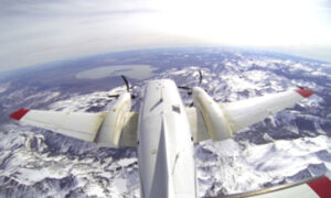
Airborne Snow Surveys

Overview
Learn more about the importance of snow surveys as a critical resource tool:
- Click HERE for Airborne Snow Survey Backgrounder.
- KRCD blog post on ASO
- Water Blueprint for the San Joaquin Valley blog post on ASO
- View our storymap and video HERE.
OVERVIEW: The Kings River watershed in the Southern Sierra Nevada is where, on average, 1.7 million acre-feet of water supply for portions of Fresno, Kings, and Tulare counties is found stored as snow. The supply is extremely variable. In wet years it can exceed 4 million acre-feet, causing potential flood risk downstream, and can swing below 400,000 acre-feet in the driest years, straining groundwater supply used to meet demand. Water management begins with understanding and forecasting snowpack.
Forecasting water supply with the full suite of complementary snow measurement tools contributes to the daily understanding and analysis of snowpack that allows water managers to mitigate flood risk, plan for swings in supply, and increase the likelihood of putting surplus water to use.
AIRBORNE REMOTE SENSING FOR SNOWPACK (ARSS) KEY BENEFITS
- Prevent overly conservative flood releases that reduce water supply storage
- Reduce risks associated with flood releases, like crop or property damage, thanks to foresight and planning
- Anticipate and capture flood water for groundwater recharge, offsetting groundwater use and replenishing supplies, a priority under CA’s SGMA regulation
- Continue to balance environmental flows while aligning water supply expectations with urban and agricultural users
- Provide insight into potential drought conditions
- Help cities plan their water management strategy, offsetting groundwater pumping to meet the needs of homes, businesses, and industry
KINGS RIVER: $2,200,000 annually
ALL CA DWR SNOWPACK FORECAST BASINS: $35,000,000 annually
WESTERN U.S.: $70,000,000 annually
Funding for 10 flights per water year would provide optimal high-resolution snowpack information throughout the snow accumulation and melt periods. *In California, the program is immediately scalable across existing “High Sierra” programs in the Kaweah, Kings, San Joaquin, Merced, and Tuolumne watersheds and could be scaled quickly in the Feather and Yuba watersheds.
The program is scalable across western US watersheds should funding be made available.